
DAILY UPDATE: Tuesday, 9/30/20
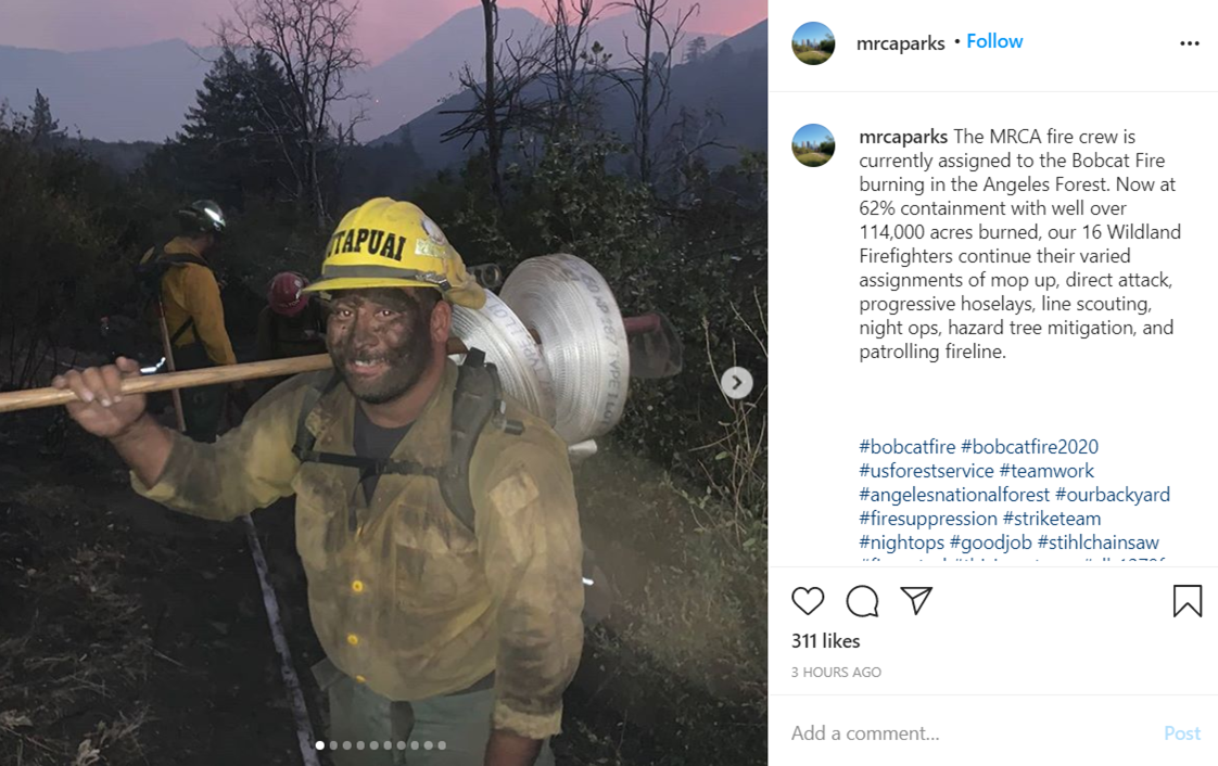
LATEST updates @Angeles_NF: The #BobcatFire, after 3 weeks of hard work, is winding down. There are just a few areas left with interior fire activity. The main work left is mopping up, back-hauling equipment and trash and patrolling along the containment lines.
More info at http://go.usa.gov/xGkmW
BOBCAT FIRE INCIDENT DETAILS @INCIWEB
LATEST BOBCAT FIRE UPDATES @Angeles_NF
BOBCAT FIRE UPDATES @ LA COUNTY FIRE
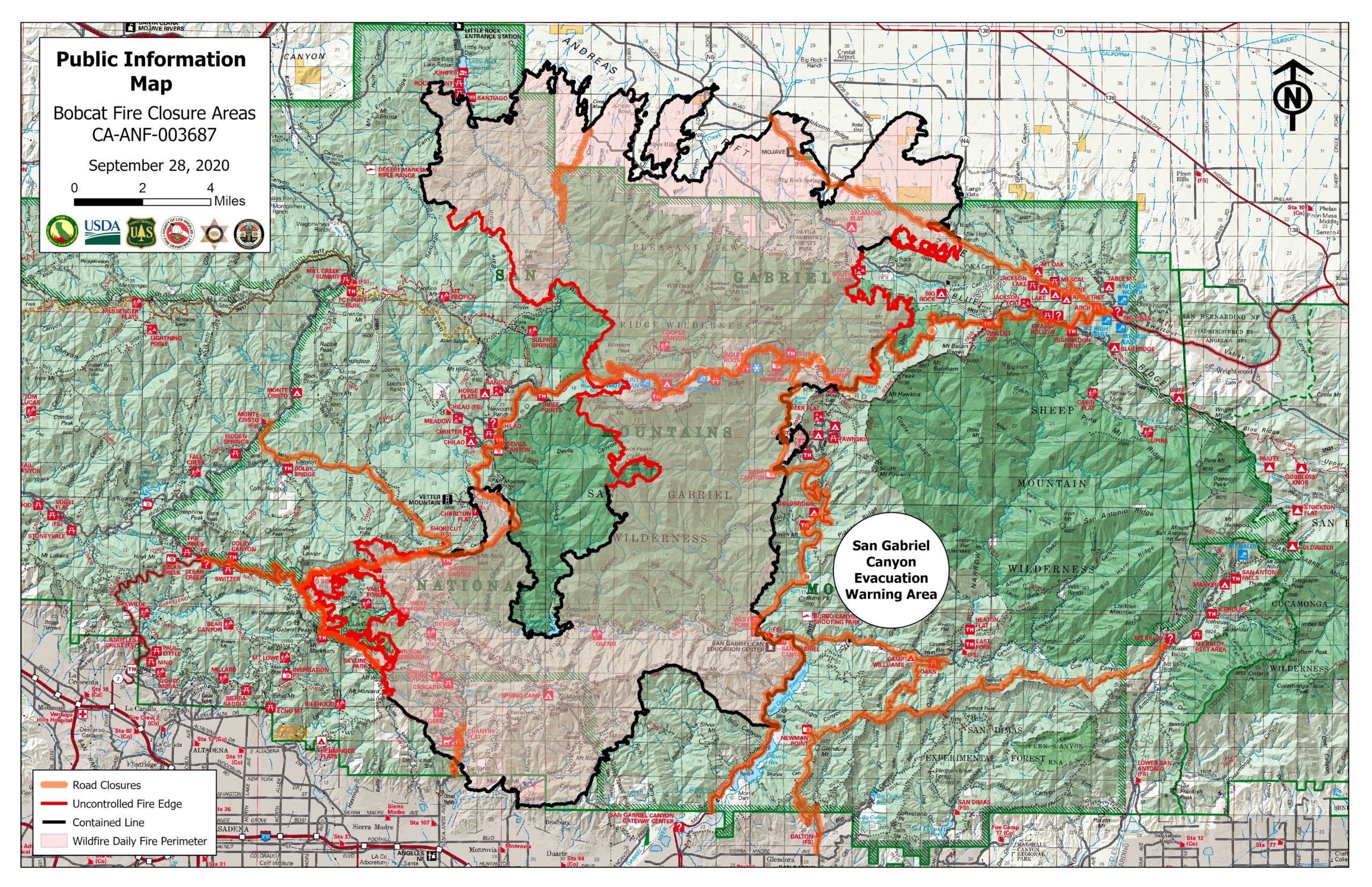
READY LA COUNTY – EMERGENCY EVACUATION MAP
SOUTHCOAST AQMD – AIR QUALITY REPORT HERE
All of the fire updates and community meeting videos are available on the: Bobcat Fire YouTube Channel: bit.ly/3iQy9zp
(DOWNLOAD LATEST FIRE UPDATE HERE)
TODAY: Tuesday – 9/30 – Bobcat Fire Daily Update
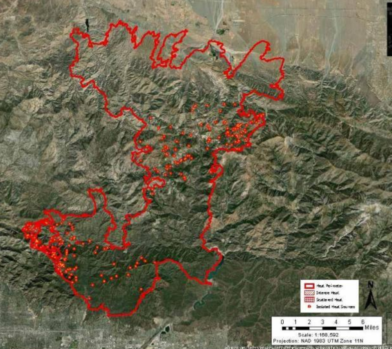
Today firefighters will continue to strengthen containment lines. On the northwestern portion of the fire, crews are working from Highway 2 to Little Rock Reservoir constructing handlines and mopping up. Patrols continue along the northern portion of the fire to make sure communities are secure and staying alert for any potential new activity. Heavy mop-up will continue northwest of Mount Wilson from Mt. Wilson Red Box Rd to Highway 2. In the northeast portion of the fire near Mount Waterman, mop up and patrol activities continue. The southern perimeter of the fire remains moderated and in patrol and mop-up status from Mt. Wilson around to Crystal Lake. On the south and east sides of the fire crews will begin the process of pulling hose and backhauling equipment. They will also begin suppression repair work on contingency lines.
YESTERDAY:
There was minimal fire growth yesterday and last night. Fire crews focused on strengthening containments lines, monitoring areas for spot fires, and looking for opportunities to attack the fire directly. Heavy mop-up occurred in the Mount Wilson area from Mt. Wilson Red Box Rd to Highway 2. Crews continued to monitor, patrol, and clean up the Pinon Ridge area to secure containment lines. Firefighters monitored fire activity near the Manzanita Trail and found opportunities to fight the fire directly with the assistance of aviation assets. For the past few days, fire activity on the eastern side of the fire has moderated on the northern portion of the Highway 39 corridor to the San Gabriel Reservoir.
WEATHER:
Strong high pressure anchored over the west will maintain hot and dry conditions over the region with much above normal temperatures at least through Friday. Temperatures will peak near 100 degrees over the lower elevations of the fire tomorrow and Thursday before a slight cooling trend begins over the weekend. Humidity in the low teens with poor overnight R/H recovery will continue for the next several days. A mostly light diurnal wind pattern will prevail at the lower elevations of the fire with light north-northeasterly winds over the upper elevations for the next few days. A Heat Advisory has been extended through 8pm Friday for the San Gabriel Mountains and surrounding areas.
EVACUATION ALERTS
**No repopulation or lifting of any warnings occurred yesterday. All orders remain the same. For more information visit: https://rb.gy/flykjl.
Evacuation Orders:
Paradise Springs – South of Big Pines Highway, east of Devil’s Punchbowl, west of Largo Vista Road, and north of the forest.South and west of Upper Big Tujunga Canyon, east of Angeles Forest Highway, and north of Angeles Crest Highway.Residences along Angeles Crest Highway, between Angeles Forest Highway and Highway 39.
Evacuation Warnings:
South of Big Pines Highway, east of Largo Vista Road, west of 263rd Street E (County line), and north of the forest.South of Mount Emma Road, north of Upper Big Tujunga Canyon, east of Angeles Forest Highway, and west of Pacifico Mountain.East Fork Areas: Julius Klein Conservation Camp 19, Camp Williams, and the River Community.
The Red Cross Evacuation Centers at Palmdale High School and Santa Anita Park are now closed. Anyone still needing assistance can call the Disaster Distress Hotline at 800-675-5799.
SUMMARY:
The Bobcat Fire started on September 6 at 12:21 PM. The fire is located near the Cogswell Dam and West Fork Day Use area. The fire is burning in heavy fuels with a rapid rate of spread.
CLOSURES
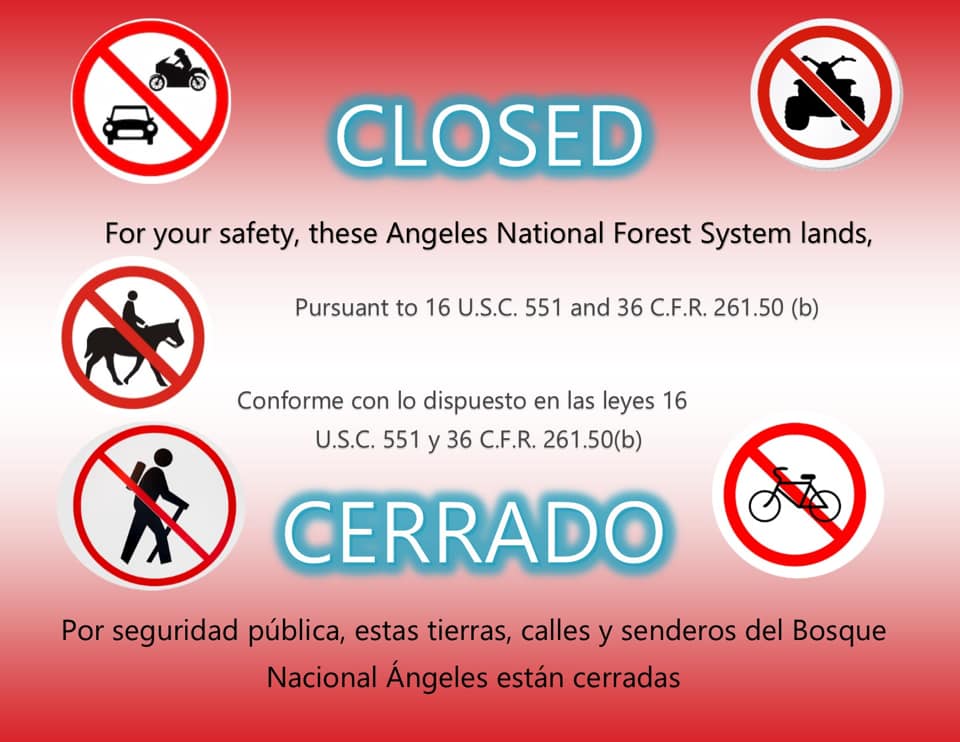
The Forest Service has extended its temporary Regional Forest Closure Order to SEPTEMBER 30th. Stay up to date on latest Forest closure info: https://www.fs.usda.gov/angeles/
Forests included in this closure are: Angeles, Cleveland, Los Padres, San Bernardino, Inyo, Sequoia, Sierra, Klamath, and Six Rivers. The Forest is closed to all general activity, including developed campgrounds and day-use sites due to wildfire threat. Prohibition of the use of any ignition sources (campfires, gas stoves, etc.).
SAFETY:
A temporary flight restriction is in place over the fire. Wildfires are a No Drone Zone. Visit Know Before You Fly: knowbeforeyoufly.org.
Road Closures
– SR 2 between Angeles Forest Highway and a point 2.2 miles east of the junction with I210. – SR 2 between Angeles Forest Highway to Big Pines. – Angeles Forest Hwy, from Sierra Hwy to Angeles Crest Hwy. – All roads leading into San Gabriel Canyon. – Hwy 39 is closed north of Azusa (8.1 miles north of the junction with I10) to SR 2. – Glendora Ridge Road, from Glendora Mountain Road to Mount Baldy Road. – Upper Big Tujunga Canyon Rd, from Angeles Crest Hwy to Angeles Forest Hwy – Chaney Trail, from Alzada Rd to Millard Canyon Campground – Chantry Flats, Arno Drive to Forest Route 2N40
For more information, please visit inciweb: https://go.usa.gov/xGkmW

For current updates go to Ready LA County website and sign up for emergency alerts at www.lacounty.gov/emergency
Also, sign up for ALERTS: NIXLE, PULSE POINT -District Fire 3
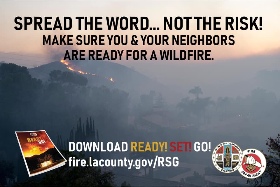
Ready!Set!Go! Your Personal Wildfire Action Plan from LA County Fire Training on Vimeo.
ALTADENA EVACUATION INFO FROM ALTADENA CERT TEAM: From Deb Halberstadt, ALD LASD CERT Coordinator:
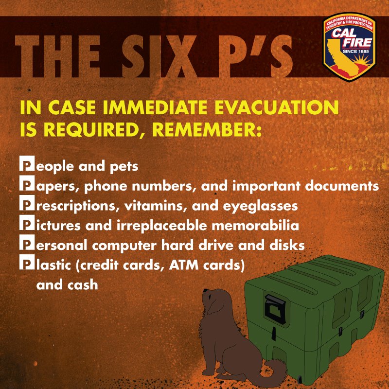
If asked to evacuate, use all southbound streets, not just Lake and Fair Oaks. Don’t go east until those streets are not crowded. Take all family, pets, go bags, and all financial records and cash.
From Anne Nowlin, Map Your Neighborhood Coordinator:
Ready, Set, Go! is a nationwide program … that educates residents about proactive measures to take before an emergency and actions to follow when communities are threatened.
BOBCAT FIRE INFO LINKS:
Heatmap-Current: https://ucanr.edu/sites/fire/Safety/Current/
Flight tracker: https://www.flightradar24.com/34.09,-118.05/11
ALTADENA AIR QUALITY VIA PURPLE AIR
STAY UP TO DATE ON WIND PREDICTIONS
SOCAL EDISON (SCE): Strong winds and Power Shut Offs
BOBCAT FIRE MEETING NOTES 9/14-HERE
SOCIAL MEDIA: #BobCatFire
Twitter: @angeles_NF @kathrynbarger @ReadyLACounty @lacofd @R5_Fire_News @RedCrossLA
Facebook: @angelesnationalforestAngeles @supervisorbarger @LosAngelesCountySheriffsDepartment @LACoFD
Locan pages/groups: @AltadenaCERT @BeautifulAltadena-Bobcat Fire @WhatsUpAltadena @AltadenaCA
Instagram: @LACountyFD
RESOURCES/INFO GRAPHICS:
DOWNLOAD COUNTY OF LA EMERGENCY SURVIVAL GUIDE
DOWNLOAD EVACUATION LOCATIONS INFO
DOWNLOAD PET DISASTER CHECKLIST