
In anticipation of the arrival of Tropical Storm #Hilary the L.A. County and Sheriff’s Emergency Operations Centers are in place. This includes our utility companies. Preparations are being made for impact to our community. By being prepared the damages and injuries will be minimized. Sign up for local alerts for where you live and work. Visit alert.lacounty.gov for a listing of emergency notification systems in use in @CountyofLA
Heavy rain and wind at times will be starting late Saturday continuing until Monday morning. This can change as the storm continues to move toward Southern California. Below are links to keep updated as we move forward over the week-end.
IMPORTANT LINKS/RESOURCES;
The National Weather Service is forecasting potential impacts to LA County as a result of Hurricane Hilary (estimated between Sunday and Tuesday). Severity of impacts and timing have uncertainty at this time but as forecasting continues, confidence levels will increase. Hurricane Hilary could result in significant rain, flash floods, severe winds, storm surge, tornadoes, dangerous surf and marine conditions. Visit this page periodically for updates as conditions warrant.

-
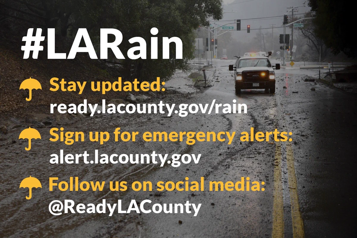
Sign up for emergency alerts at alert.lacounty.gov
-
Follow these accounts for updates: @ReadyLACounty, @NWSLosAngeles
LATEST NEWS
Former Tropical Storm Hilary has weakened and become post-tropical.
While the winds associated with this system have gone below tropical
storm strength, prompting the warning cancelation, the threat for
flooding rains will continue into Monday morning over Los Angeles
and Ventura Counties. Locally gusty winds will also continue.
Activity will decrease through the day on Monday and into the
overnight hours.
FLASH FLOOD WARNING INFORMATION:
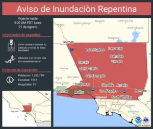
Flash Flood Warning including Los Angeles CA, Long Beach CA and Glendale CA until Monday 8/21 – 8AM PDT
— NWS Los Angeles (@NWSLosAngeles) August 20, 2023
FLOOD WATCHES are still in effect for #Ventura/#LosAngeles counties as well as parts of #SantaBarbara county. #CAwx #LARain pic.twitter.com/eM4OI3tOFq
— NWS Los Angeles (@NWSLosAngeles) August 19, 2023
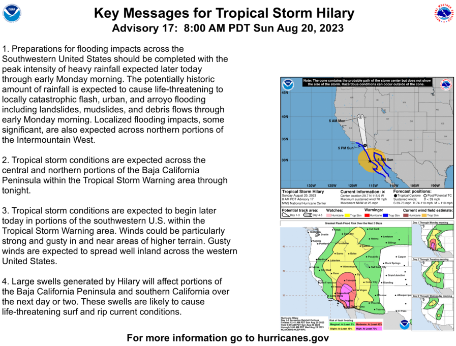
The most likely impact from Tropical Storm #Hilary will be rain. The forecast keeps high rain chances between Sunday and Monday night. Rain amounts are less certain due to the exact track and timing. #CAwx #LARain pic.twitter.com/r3RvOiseSM
#HurricaneHillary just before the sun rose this morning. Hilary is currently a CAT 3, and is expected to still be a hurricane as it approaches the west coast of the Baja California Peninsula, but is forecasted to weaken to a #TropicalStorm before it reaches #SoCal. pic.twitter.com/f558vlktnJ
Updated rainfall graphic from the folks at @NWSCNRFC.

-
For safety tips and resources, and stay up to date at: ready.lacounty.gov/rain
-
Have A Plan from Los Angeles County Newsroom on Vimeo.
|


Second Update from Public Works 8PM:
Los Angeles County Public Works continues to monitor the Hurricane Hilary storm off the Mexican coast that is forecast to come into Southern California with showers beginning Sunday, August 20, and intensifying late in Sunday and into Tuesday next week.
The latest National Weather Service briefings have promoted Public Works to amplify warnings about wind and potential rain intensity.
We are now anticipating high winds and potential one-hour rain intensities that have prompted our engineers to declare what we call a Phase 3 mud and debris flow warning, which means and burn area with less than three years recovery could experience substantial mudflow and resulting damage; burn areas with more than three years recovery are susceptible to moderate mud and debris flows. (See the Debris and Mudflow Potential Forecast for communities that may be affected.)
Rain is currently forecast to be 2 to 3 inches in coastal areas and 4 to 6 inches in the mountains and foothills, but intensities could be more than one inch an hour in some parts of the County. The Antelope Valley communities north of the San Gabriel Mountains may see heavier rain impact. The storm is expected to come with winds up to 45 mph with possible higher gusts.
The public infrastructure managed by LA County Public Works is ready to protect communities from flood danger and capture as much rain as possible to recharge local groundwater supplies, as we have throughout this year to date.
In recent burn areas, there is collaboration across multiple County and municipal agencies to protect the public from potential mud and debris flows.
Our road crews are mobilized for downed trees or other road issues.
=================================================
Tropical Storm Update from LA County Public Works: 12PM
Los Angeles County Public Works continues to monitor the Hurricane Hilary storm off the Mexican coast that is forecast to come into Southern California with showers on Saturday, August 19, and intensifying Sunday, August 20, and into Tuesday next week.
Our partners at the National Weather Service have been able to provide a better (but still developing) idea of the course of the storm and what its potential impacts might be on Los Angeles County.
Rain is currently forecast to be 2 to 3 inches in coastal areas and 4 to 6 inches in the mountains and foothills. The Antelope Valley communities north of the San Gabriel Mountains may see heavier rain impact. The storm is expected to come with winds up to 35 mph.
The public infrastructure managed by LA County Public Works is ready to protect communities from flood danger and capture as much rain as possible to recharge local groundwater supplies, as we have throughout this year to date.
In recent burn areas, there is collaboration across multiple County and municipal agencies to protect the public from potential mud and debris flows.
LA County Public Works weather forecasters and engineers warn of possible moderate debris or mudflow in recent burn area with less than three years recovery, and isolated debris and mudflows for burn areas with less than four years of recovery. (See the Debris and Mudflow Potential Forecast for communities that may be affected.)
We will continually monitor the burn areas and report on any changes that may develop via our Twitter (X) page at @LACoPublicWorks.
For further information or want to report storm-related incidents, please contact the Public Works 24/7 Dispatch Center at (800) 675-HELP (4357).
Be Safe,
|
||||
|

Dear PUSD Community,
I want to inform you about the decision we have made regarding our schools due to the impact of Hurricane Hilary.
The National Weather Service has issued a tropical storm warning for Hurricane Hilary from now until Monday night that will affect Los Angeles County and areas of Southern California with high winds. A flash flood warning has been issued for Southern L.A. County with a potential several inches of water and higher in certain areas.
We are advised to continue preparing for the impacts of the storm and expect roadway flooding, wind damage, and power outages.
With the safety and well-being of our students, employees, and their families as our highest priority, we have decided to close PUSD schools tomorrow, Monday, August 21, 2023. We want everyone to stay safe and avoid any unnecessary travel or exposure to dangerous road conditions. This includes athletic events and any third-party activities on PUSD campuses.
The Superintendent’s Leadership Team, school administrators, and maintenance and operations workers including, head custodians, are required to report to their sites at 10 a.m. on Monday. If it is unsafe for employees to travel, they are to talk with their supervisors. Other employees are to stay at home unless they hear from their supervisors.
Recognizing that many of our students rely on school meals, PUSD will offer Grab and Go meals for students at a limited number of locations. We will inform you about the locations shortly.
We expect to reopen schools and resume normal operations on Tuesday, August 22.
Thank you for your understanding and cooperation during this time.
Please check for PUSD messages via email, text, and phone calls. Updates will also be posted on the District’s website at www.pusd.usand our social media.
Please stay safe, stay home, and stay informed.
Sincerely,
Elizabeth J. Blanco, Ed.D.
Interim Superintendent


