
ALTADENA, CALIFORNIA
an abbreviated history for the internet by Mike Manning
The indigenous inhabitants of Altadena, and Pasadena, were the Hahamog-na1, a Tongva2 Native American tribe who lived in the Arroyo Seco. Hahamogna3, the Chief, was met by General Portola of the Mexican Army in 1770 as he was making an exploratory expedition of Alta California. With the establishment of the San Gabriel Mission (1773) and the City of Los Angeles (1781), the south lands of California were properties claimed in the name of the King of Spain.
Altadena is the northernmost portion of Rancho San Pascual as established by the Mexican Government in 1826 after they had claimed independence from Spain. California was annexed in the Treaty of Guadalupe Hidalgo in 1848 and became a state in 1850. The Mexican Ranchos were then open to settlement from other parts of the Country. Rancho San Pascual was settled by the Indiana Colony in 1874 and incorporated as Pasadena, a Chippewa name derived from a translation for “Crown of the Valley”, in 1886. The highland areas, such as Altadena, remained undeveloped areas of the Los Angeles County.
1. The pronunciation is hah – hah – mow – gnaw. Modern spelling is Hahamongna pronounced ha – ha – mung – guh.
2. The Tongva Indians are of the Shoshone language group, but the language is Tongva.
3. The tribe, which constitutes a small family group, is called by the chief’s name. Hahamogna assumed the Christian name Pascual from San Pascual upon his conversion. The tribe was then known as the Pascualite Indians. The choosing of this name is totally separate from the naming of Rancho San Pascual.
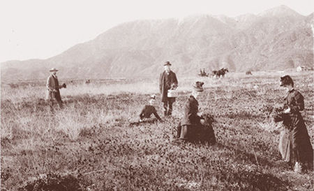
The famous poppy fields of Altadena. This photo taken around 1875 to 1880 looks northwest across Altadena toward Millard Canyon.
In 1880, Capt. Frederick and his brother John Woodbury of Marshalltown, Iowa, purchased 937 acres known as the Woodbury Ranch. John Woodbury established the Pasadena Improvement Company in 1887 with a plot plan of residential development referred to as the Woodbury Subdivision. To attach a name to the community, they contacted Byron O. Clark who had established a nursery in the foothills in 1875 and had since moved away. He called his nursery “Altadena Nursery”, a name he coined from the Spanish “alta” meaning “upper” and “dena” from Pasadena 4. Since Clark had moved away, Woodbury asked if he could use the name Altadena for his subdivision. Clark agreed.
The 1930’s idea that Altadena came from an Italian concoction of “alta-eden” was contrived by members of the newly organized Altadena Chamber of Commerce in order to glamorize the burgeoning community. It has no basis in history.
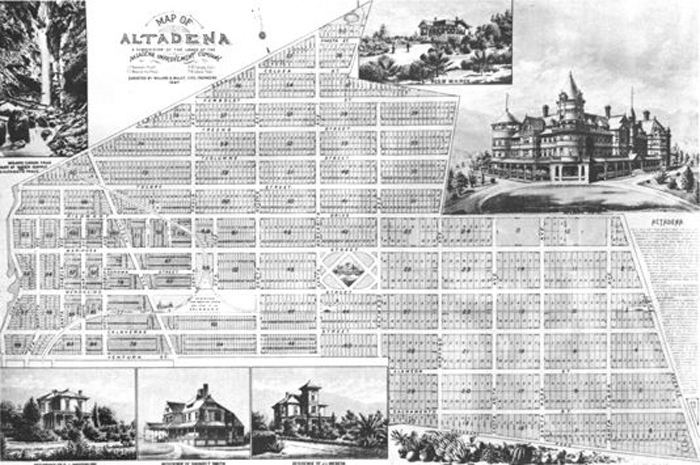
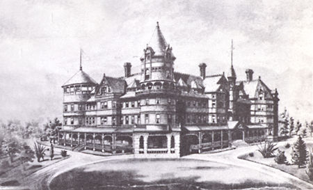
The original development rendering shows an Altadena Hotel, a railway yard that ran south to San Pedro and north onto Salt Lake City, and streets named for California counties running east and west, and avenues named for Spanish female saints running north and south. Some of these street names still exist today: Mariposa, Mendocino, Calaveras, Alameda, Sacramento, Santa Rosa, Santa Anita. El Molino was named Santa Clara, Fair Oaks was Santa Margarita, Olive Street was Santa Barbara. Lake Avenue was named for a lake that existed in Pasadena, not Lake County. But names like Shasta, Humboldt, Tulare, Santa Inez, Santa Maria and Santa Isabela were never realized.
4. The name Pasadena is derived from a Chippewa word pa-sa-de-na meaning “of the valley.” City Father Dr. Thomas Eliot, in search of a proper postal name for the new Indiana Colony, had requested of a missionary friend of his back in Minnesota to send a Native American translation for the term “Crown of the Valley.” The reply was, “Weo-quan pa-sa-de-na,” or “hat of the valley.” The founding fathers, finding the pa-sa-de-na phrase so euphonious, elected to name the new town Pasadena.
ORIGINAL COMMUNITY PLAN OF ALTADENA
Pasadena Improvement Company in 1887
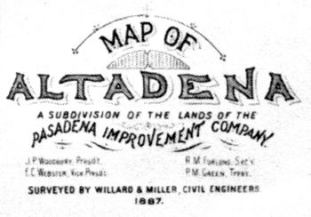 |
John Woodbury established the Pasadena Improvement Company for the purpose of developing the subdivision he named Altadena. John served as its president. E. C. Webster, who started the Green Hotel in 1887, was vice president; and Perry M. Green, president of Pasadena First National Bank, was its treasurer. |
 |
|
The proposed Altadena Community Plan of 1887. |
 |
|
The proposed Altadena Hotel (never realized)
|
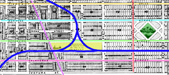 |
| The proposed Altadena Hotel, in the green diamond to the right, and the proposed railroad yard and Y, the yellow just left of center. The yard is marked S.P., L.A. & U.R.R., The San Pedro, Los Angeles & Utah Railroad. Blue marks the proposed right-of-way, and marks the present-day Harriet Street. Only the east-west trunk of the railroad was laid. The railway line failed before a Salt Lake City run could be established. The streets are marked: east to west: orange, Piedmont Dr., present-day Altadena Drive; light blue, Mariposa St.; light green, Mendocino St.; pink, Calaveras St.; north to south: violet, Lincoln Avenue coming up from Pasadena; and red, Santa Margarita, now Fair Oaks. |
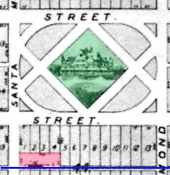 |
| The proposed Altadena Hotel, in the green diamond, and a train station, in pink, on the L. A. Terminal line, blue. Of these three only the railroad line was built and opened officially on January 31, 1888. This section of track was taken up in 1916. Parts of it are marked by Harriet Street to the west and narrow lots filled in by residences or otherwise assumed by existing tracts along Calaveras and Mendocino Streets. It ended up about where the Altadena Post Office stands today.Notice the “street” above is Mariposa, the “street” below is Mendocino, “Santa” Margarita (Fair Oaks) is to the left, and Raymond is to the right. |
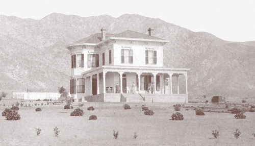
Frederick Woodbury, a retired military officer, built his home on the Ranch in 1882. It still stands at the top of Madison Avenue in Altadena behind the Sheriff’s Department on El Molino.
|
A plan to build a mansion for John Woodbury at the northwest corner of Santa Rosa was proposed with a long driveway leading up from the Pasadena limit. The drive was planted with two year old Deodar cedar trees grown by Frederick behind the house from seeds brought from Italy by John. This mile long drive of trees has become the world famous Christmas Tree Lane.
The newly sprouted community of Altadena immediately began to attract millionaires from the East. In 1887 Andrew McNally, the printing magnate from Chicago and his good friend Col. G. G. Greene had built mansions on what was to become Millionaire’s Row, Mariposa Street near Santa Rosa. Col. Jabez Banbury, a comrade-in-arms of Frederick Woodbury, built a gorgeous Italianate Victorian house near the west end. Newspaper moguls Armiger Scripp and William Kellogg built side by side just east of Fair Oaks Avenue.
The Southern California land boom busted in 1888, not before the L.A. Terminal Railway was laid through town. But the high ideal of Altadena becoming a real estate dividend all but dwindled for the Woodburys. Still the community grew with wealthy speculators from the East, some seeking fairer weather, some better health, some real estate opportunities, some retirement. The community would grow, but at a slower pace than the Woodburys expected.
The Woodbury development accounts for that which happened west of Lake Avenue and south of Altadena Drive, what they called the Piedmont. Parts of the east side, generally passed Pepper Drive was a west portion of Rancho Santa Anita, essentially Arcadia today. Judge Eaton and Dr. Griffin purchased the land that ran to Eaton Canyon to add to the Ranch communities that settled the east side. Craig Ranch, Grogan Ranch, Fair Oaks Ranch and the Sphinx Ranch were all major contributors to the settlement of East Altadena.
Moving into the twentieth century, the vanguard of Altadena pioneers began to change, and with it came more community development, more philanthropy, more services, and more venues. Lafayette S. Porter (from 1887-1932) bought and developed large parcels near the Rubio Wash. The Altadena Country Club (from 1911-1944), now the Altadena Town & Country Club, had an 18-hole golf course that extended to Allen Avenue. There was an airport adjacent to the country club (1919-1921) that was established by Cecil B. DeMille.
The Altadena Country Club Parks development, where the Balian mansion stands, was opened in 1912, and Altadena Woods, where the “president” streets are, was developed in the late 1920’s. Famous western novelist Zane Grey bought the 1907 Woodward house near Marengo and Mariposa in 1920. Mrs. Grey helped establish the Altadena Library District in 1926, and was its first Board President.
Prof. Lowe’s world famous Mt. Lowe Railway, opened in 1893, became part of the Pacific Electric Red Car system until 1936, and the Red Car ran into Altadena until 1941. Gen. Farnsworth developed an uninteresting piece of Forestry Department property at Lake and Concha in 1928 to become Altadena (now Farnsworth) Park. In 1934, the Recreation Building on Mount Curve, later to be named the William B. Davies Building, was added to the park through funding by the WPA. In 1938, Davies also secured WPA funding for the Altadena Library Building on Lake Avenue. The library moved to its present location on Mariposa replacing the Col. Greene mansion in 1968.
 |
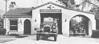
The Altadena Fire Department was established in 1924 with Engine No. 11 housed at the corner of Marcheta Street and Lake Avenue. In 1925 a more suitable station was built on Foothill Blvd., now Altadena Dr., just east of Lake. |
 |
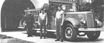
The Lincoln Avenue Station No. 12 was added in 1928… |
 |
…and a Station 52 was built on Allen above Woodbury in 1946. |
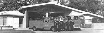 |
The present Fire Station No 11 was designed by Altadena architect Oscar Werner and built in 1955. |
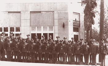 |
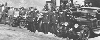
The Altadena Sheriff’s Station No. 7 was opened in 1927 next to the fire station on Altadena Drive. (as seen in first panel)It moved to the northeast corner of Mariposa and Lake in 1930… |
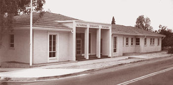 |
…then to the present station which was built in 1948. |
The grandson of Andrew McNally, Wallace Neff, became a famous Southern California architect. He started his career in Altadena with the design and construction of St. Elizabeth Catholic Church (parish est.1918) which was dedicated in October of 1926. The Church at the northeast corner of Calaveras and El Molino was originally a Methodist-served community church until 1934 when during the depression a Baptist society took over forming the Altadena First Baptist Church. The Altadena Community Church on Altadena Drive just east of Lake was dedicated in 1948. St. Marks Episcopal Church was begun as a mission in 1909, but grew to finally building a prish church on Altadena Drive just east of Lake in 1948.
Altadena school, known as the Calaveras school has been at its present location, given some expansion, since 1906. St. Elizabeth School opened in 1919. Eliot Middle School was completed in 1931 and named for Charles W. Eliot, President of Harvard College. Eliot had visited Altadena in the past looking at establishing observatories on Mt. Wilson and Mt. Harvard.
Over the years Altadena has been subject to annexation by Pasadena. Annexation was stopped in 1956 by the collective will of the community though it has been resurrected several times since without success.
At this point you may want to take the oportunity to view a 1906 Panorama of Altadena and the southland from above the Famous Mt. Lowe Railway and Echo Mountain. This exceptionally large page will need to be scrolled from far left to far right. Because of its extraordinary size (3000 x 460 pixels) it may take an exended amount of time to downlaod. If you choose to view this page, click here to go to the Altadena Panorama. A special thanks goes out to Charlie Seims for allowing me to use this photo from his collection.
New on this website is a satelite view of Altadena. Because of its extraordinary size (779 x 562 pixels) it may take an exended amount of time to downlaod. If you choose to view this page, click here to go to the Satelite map .
Or go to the Official Altadena Timeline, an unabridged version of what was printed in Altadena Historical Society’s Altadena: Between Wilderness and City.


